


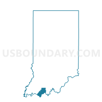
OHIO 01, Spencer County, Indiana
About
Outline

Summary
| Unique Area Identifier | 580621 |
| Name | OHIO 01 |
| County | Spencer County |
| State | Indiana |
| Area (square miles) | 0.46 |
| Land Area (square miles) | 0.43 |
| Water Area (square miles) | 0.03 |
| % of Land Area | 93.06 |
| % of Water Area | 6.94 |
| Latitude of the Internal Point | 37.88144530 |
| Longtitude of the Internal Point | -87.04896980 |
Maps


Graphs
Select a template below for downloading or customizing gragh for OHIO 01, Spencer County, Indiana


Neighbors
Neighoring Voting District (by Name) Neighboring Voting District on the Map
- OHIO 02, Spencer County, IN
- OHIO 03, Spencer County, IN
- OHIO 04, Spencer County, IN
- OHIO 06, Spencer County, IN
Top 10 Neighboring County Subdivision (by Population) Neighboring County Subdivision on the Map
Top 10 Neighboring Place (by Population) Neighboring Place on the Map
Top 10 Neighboring Unified School District (by Population) Neighboring Unified School District on the Map
Top 10 Neighboring State Legislative District Lower Chamber (by Population) Neighboring State Legislative District Lower Chamber on the Map
- State House District 78, IN (77,639)
- State House District 74, IN (61,219)
- State House District 18, KY (43,650)